March 2025
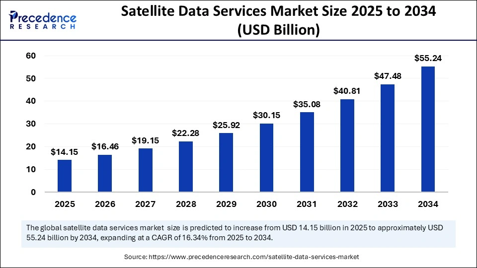
The global satellite data services market size is evaluated at USD 14.15 billion in 2025 and is forecasted to hit around USD 55.24 billion by 2034, growing at a CAGR of 16.34% from 2025 to 2034. The North America market size was accounted at USD 4.50 billion in 2024 and is expanding at a CAGR of 16.50% during the forecast period. The market sizing and forecasts are revenue-based (USD Million/Billion), with 2024 as the base year.
The global satellite data services market size was calculated at USD 12.16 billion in 2024 and is predicted to increase from USD 14.15 billion in 2025 to approximately USD 55.24 billion by 2034, expanding at a CAGR of 16.34% from 2025 to 2034. The increasing integration of advanced technologies, supportive government initiatives, increasing investments in space exploration, growing demand for geospatial data, rising adoption of artificial intelligence (AI), machine learning (ML), & cloud computing in the space sector, and rising focus on sustainability are expected to drive the growth of the global satellite data services market throughout the forecast period.

In today’s rapidly evolving digital landscape, the integration of Artificial Intelligence (AI) emerges as a transformative force, holding great potential to impact the growth of the satellite data services market. AI is paving the way for innovative pathways and offering unprecedented opportunities. AI in satellite imagery empowered businesses to make informed decisions by providing deeper insights and specific images of the Earth’s surface. By harnessing the power of AI, the satellite data services market is significantly improving data analysis, processing, and interpretation. Satellite data includes numerous high-resolution images and sensor data from orbit, which AI and machine learning technologies can effectively manage. AI-powered systems can effectively detect satellite imagery patterns for various applications, such as climate monitoring, agricultural yield prediction, urban planning, disaster response, and others.
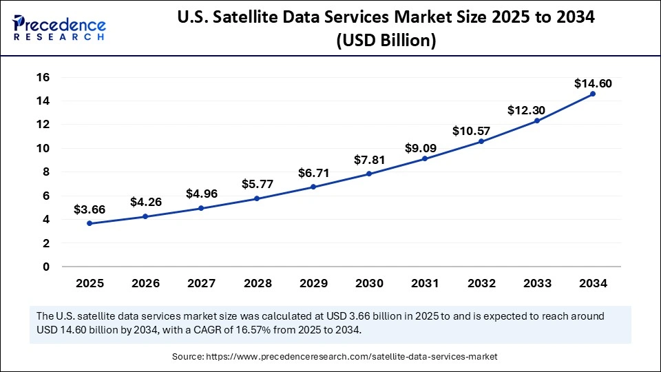
The U.S. satellite data services market size was exhibited at USD.15 billion in 2024 and is projected to be worth around USD 14.60 billion by 2034, growing at a CAGR of 16.57% from 2025 to 2034.

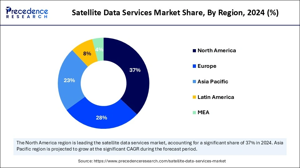
North America held the dominant share of the satellite data services market in 2024. The region has a prominent history of space exploration and is an early adopter of innovative technologies. The surge in investments from renowned government agencies, such as the Department of Defense and National Aeronautics and Space Administration (NASA), led to innovations in satellite technology and several Earth observation programs. The region is expected to sustain its position in the near future due to factors such as the presence of sophisticated advanced technological infrastructure, rising research and development expenditure, increasing awareness related to high-resolution images, and the rising focus on the development of nanosatellites, increase the use of satellite data services in urban planning and agricultural monitoring such as crop health, soil conditions, and weather patterns. The rising focus on sustainability has increased the usage of satellite data for environmental monitoring and climate analysis. Satellite high-resolution imaging services play a crucial role in tracking wildfires, pollution levels, deforestation, marine life activities, and others. Moreover, the incorporation of AI and cloud computing is significantly boosting the growth of the market by offering faster and more detailed visual representations of the Earth’s surface across North America.
Asia Pacific is expected to witness the fastest growth in the coming years. The rising investments by governments and commercial corporations in satellite infrastructure and data services drive the growth of the market in the region. Countries like India, China, and Japan are active in space exploration, having comprehensive end-to-end space capabilities and well-developed space infrastructure. The growth of the satellite data services market in Asia Pacific can be attributed to the rising need for real-time high-resolution satellite imagery in various sectors, such as agriculture, renewable energy, real estate, defense, oil & gas, and environmental monitoring. High-resolution data assists in gaining detailed insights, allowing more precise and data-driven decisions for any potential hazards.

Europe is observed to expand at a notable growth rate during the forecast period. The growth of the European satellite data services market can be attributed to the growing need for high-resolution imaging services, rising investment in Earth observation satellites, rising demand for real-time data, and integration of AI and ML technologies. In addition, the growing government focus on the development of the space exploration industry is expected to fuel the market’s growth in the coming years. The increasing collaborations between national defense agencies and EU bodies supporting satellite-based maritime surveillance to increase the safety of coastal areas and several supportive government policies promote the development and use of satellite data services in a variety of fields like agriculture, forestry, disaster management, weather forecasting, environmental monitoring, urban planning, and national security support regional market growth. Several European countries use satellite data services to effectively monitor maritime activities across borders, track illegal fishing, and enhance national piracy, mainly in the Mediterranean and the Baltic regions.
As technology continues to evolve, the demand for real-time data is steadily rising. Satellite data services play a crucial role in driving innovation and assisting in making data-driven decisions in an increasingly complex world. Satellite data service involves gathering information about the Earth by satellites in their orbits. It is a valuable source for obtaining information about planet surface changes and weather. Satellite data services rely on radio waves to transmit and retrieve data. Satellite metacommunication is an ideal option in remote areas or small locations with an unavailability of high-speed Internet or data connectivity. With the assistance of imaging satellites, satellite data services can capture images of Earth or other planets. Satellite data services often include metrics collection in all weather, including cloudy conditions and nighttime, by effectively using radar satellites. Satellite data is crucial for aiding disaster management, monitoring environmental shifts, and offering geospatial intelligence.
| Report Coverage | Details |
| Market Size by 2034 | USD 55.24 Billion |
| Market Size in 2025 | USD 14.15 Billion |
| Market Size in 2024 | USD 12.16 Billion |
| Market Growth Rate from 2025 to 2034 | CAGR of 16.34% |
| Dominated Region | North America |
| Fastest Growing Market | Asia Pacific |
| Base Year | 2024 |
| Forecast Period | 2025 to 2034 |
| Segments Covered | Service, Deployment, Application, End Use, and Regions |
| Regions Covered | North America, Europe, Asia-Pacific, Latin America and Middle East & Africa |
Increasing Demand for Real-time Satellite Imagery Data
The growing demand for real-time satellite imagery data is driving the growth of the satellite data services market. Satellite imagery data finds applications across various sectors, including agriculture, environment, maritime, disaster response, defense, mapping, civil engineering, resource management, urban planning, and utilities, as it provides valuable insights and optimizes their operations. Satellites continuously collect data about Earth by orbiting the planet and provide a broad picture of the planet’s environment, ranging from maritime activities and weather patterns to human activity monitoring and land cover area.
High initial investment
The high initial investment is anticipated to hamper the growth of the satellite data services market. Satellite data services require a high capital investment in satellites. In addition, design and operational challenges are likely to limit the adoption of satellite data services.
Supportive Government Initiatives and Rising Investments
The favorable government initiatives, along with the rising investment in advancing space exploration, are projected to offer lucrative opportunities to the satellite data services market during the forecast period. Several governments around the world are increasingly focusing on developing satellite programs to strengthen their capabilities in collecting and utilizing valuable data for infrastructure development, national security, and resource management. AI-powered satellite imagery assists governments in addressing and predicting various emerging issues, including deforestation, monitoring maritime activities, environmental changes, and others. Moreover, governmental support encourages private-sector participation, which significantly fuels the market's growth.
The image data services segment dominated the satellite data services market with the largest share in 2024. The growth of the segment is majorly driven by the increasing demand for high-resolution satellite imagery across industries such as energy, military& defense, forestry, agriculture, environmental monitoring, and real estate. In addition, the increased demand for remotely sensed imaging bolstered the growth of the segment. Remote sensing is widely utilized to gather data for numerous applications, including mineral and water exploration, hydrocarbon exploration, and geological mapping.
On the other hand, the data analytics services segment is expected to expand at the fastest rate during the forecast period. This is mainly due to the rising demand for critical and actionable insights for various applications in precision agriculture, weather forecasting, national security, and urban planning. The adoption of advanced technologies such as AI and big data has substantially enhanced the capacity to extract valuable patterns from massive amounts of satellite imagery and geospatial data. Governments and businesses increasingly rely on satellite-based analytics to make real-time decisions, risk assessments, and predictive modeling.
The private segment held the largest share of the satellite data services market in 2024. The growth of the segment is fueled by the increased involvement of commercial satellite operators to obtain critical insights about the Earth’s surface. Moreover, there is a strong emphasis on Earth observation. The increased need for real-time and accurate satellite imagery data and geospatial analytics augmented the segment.
Meanwhile, the public segment is expected to grow significantly during the projection period. Governments around the world are heavily investing in various space programs and earth observation missions. Renowned regulatory bodies such as the Indian Space Research Organisation (ISRO), National Aeronautics and Space Administration (NASA), European Space Agency (ESA), and defense organizations are demanding satellite data services for a wide range of applications, such as disaster management, border surveillance, weather patterns, and climate change monitoring, bolstering the segment’s growth.
The defense & security segment accounted for the highest share of the satellite data services market in 2024. The growth of the segment is driven by the increasing geopolitical tensions and rising concerns about national security. Satellite data services are extensively used to enhance military security and surveillance, which is critical for defense organizations. The integration of artificial intelligence and machine learning in analyzing satellite data significantly enhances the defense agencies' capabilities. In addition, the surge in government investments in satellite surveillance to obtain real-time data that aid in immediate response efforts contributes to segmental growth.
On the other hand, the environmental & climate monitoring segment is expected to grow at the fastest rate in the coming years due to the increasing awareness of climate change and the rising need for environmental protection. There is a strong focus on effectively monitoring and managing natural resources for the betterment of ecosystems. The rising focus on sustainability further increases the need for satellite data to visually represent critical insights into deforestation, weather patterns, air pollution, and land covering areas. For policymaking related to environmental management, governments and research organizations usually rely on satellite real-time imagery data. Such factors are anticipated to propel the segment’s growth in the coming years.
The commercial segment held the largest share of the satellite data services market in 2024. Several businesses, including logistics, construction, energy, real estate, mining, and telecommunications, use satellite imagery data for site selection, optimization of supply chain, and others. Satellite data assists these businesses in extracting actionable insights, helping in decision-making.
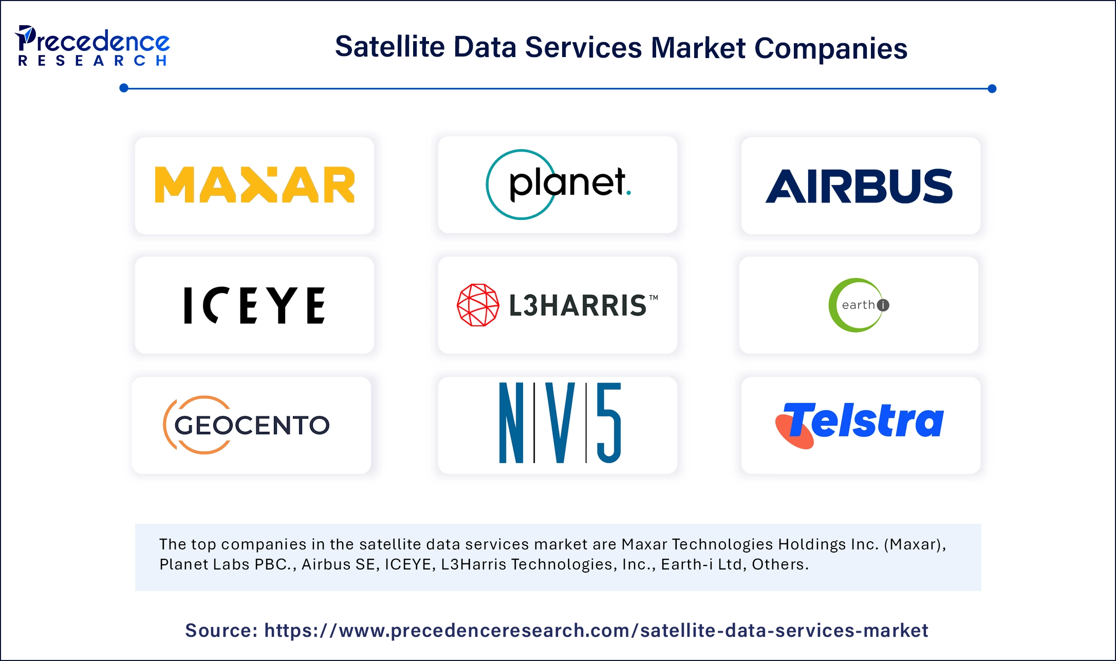
On the other hand, the service providers segment is expected to grow at the highest CAGR in the coming years. Satellite providers like Maxar Technologies, ImageSat International, and Capella Space provide actionable and high-resolution imagery insights to support multiple applications across various industries, such as agriculture, defense & military, urban planning, weather forecasting, disaster management, and environmental monitoring. The rising need for tailored services for global defense and emergency response is expected to support segmental growth.

By Service
By Deployment
By Application
By End-use
By Region
For inquiries regarding discounts, bulk purchases, or customization requests, please contact us at sales@precedenceresearch.com
No cookie-cutter, only authentic analysis – take the 1st step to become a Precedence Research client
March 2025
January 2025
November 2024
February 2025